Oregon Tourism Photo Dashboard
Handcrafted Meteorological Ephemeris & Ethical PNW Waypoints
A hand-crafted meteorological and solar ephemeris dashboard pairing real-time NOAA National Weather Service feeds, US Naval Observatory sun/moon data, and Leave-No-Trace Oregon waypoints.
Architecture Highlights
- •Handcrafted Astro & TypeScript engine querying NOAA NWS and US Naval Observatory APIs.
- •Real-time solar zenith and twilight angle ephemeris calculating golden and blue hour windows.
- •Dynamic optical exposure calculator tailored for Pacific Northwest lighting contrasts.
- •Leave-No-Trace ethical waypoint generalization protecting fragile wilderness blooms.
Engineering Hurdles Solved
- •Harmonizing live astronomical sun/moon ephemeris with changing maritime weather patterns.
- •Preventing wilderness erosion and wildflower trampling through responsible trailhead routing.
Executive Overview
The Oregon Tourism Photo Dashboard is a handcrafted environmental telemetry and lighting companion built specifically for outdoor photographers, trail stewards, and Pacific Northwest travelers. Programmed entirely by hand using Astro, TypeScript, and vanilla CSS, the dashboard operates with zero third-party trackers, zero advertising pixels, and zero artificial bloat.
Rather than relying on generic commercial forecast portals, the platform connects directly to public scientific endpoints: the National Oceanic and Atmospheric Administration (NOAA) National Weather Service and the United States Naval Observatory (USNO) Astronomical Applications Department.
“If an explorer is packing delicate camera bodies into the Columbia River Gorge or ascending Mount Hood at dawn, they don’t need marketing cookies or algorithmic feeds — they need honest, physics-grounded light and weather data.”
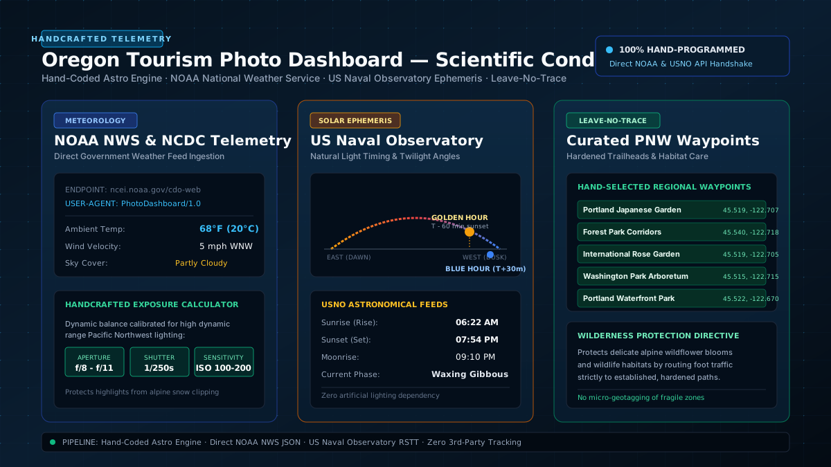
The dashboard calculates solar elevation, twilight phases, wind velocity, and ambient moisture, providing photographers with exact exposure recommendations while keeping delicate wilderness habitats safe.
Technical Architecture & Public Data Feeds
The engine runs directly inside the client browser and Astro static/SSR pipeline, orchestrated through src/types/weather.ts:
1. United States Naval Observatory (USNO) RSTT API
Queries astronomical Rise/Set/Transit/Twilight data directly from https://aa.usno.navy.mil/api/rstt/oneday:
- Solar Ephemeris: Computes exact sunrise, sunset, and solar zenith angles: $$\cos(\theta_z) = \sin(\phi)\sin(\delta) + \cos(\phi)\cos(\delta)\cos(\omega)$$
- Photographic Windows: Pinpoints the 60-minute Golden Hour prior to sunset and the 30-minute Blue Hour post-sunset twilight arc.
- Lunar Phase Telemetry: Ingests lunar rise/set vectors and current illumination cycle (e.g., Waxing Gibbous, Full Moon) for night-sky long-exposure planning.
2. NOAA National Centers for Environmental Information (NCEI)
Fetches localized climate and barometric telemetry from https://www.ncei.noaa.gov/cdo-web/api/v2/data:
- Ambient Temperature & Moisture: Tracks high/low thermal ranges and precipitation probability.
- Wind Vector Analysis: Monitors speed and heading (e.g.,
5 mph WNW) to assist outdoor shooters in anticipating water reflections vs. wind-whipped chop across mountain lakes.
3. Handcrafted Exposure Calculator
Translates real-time cloud cover and solar angle into mechanical camera settings:
- Landscape Aperture: Calibrated between
f/8.0andf/11to maintain corner-to-corner diffraction-limited optical sharpness across wide-angle primes. - Shutter Speed: Defaulted to
1/250sto freeze wind-fluttered Douglas fir foliage without introducing motion blur. - Base Sensitivity: Enforces
ISO 100 - 200to maximize sensor dynamic range and prevent blown alpine snow highlights.
Ethical Wilderness Stewardship (Leave No Trace)
A core pillar of the Oregon Tourism Photo Dashboard is environmental ethics:
- Anti-Micro-Geotagging: In strict alignment with Leave-No-Trace principles, coordinates are generalized to established regional waypoints (e.g., Portland Japanese Garden, Forest Park trailheads, Washington Park Arboretum) rather than fragile off-trail wildflower blooms or delicate moss gardens.
- Hardened Surface Preservation: All waypoint directions emphasize designated overlooks, boardwalks, and hardened viewing platforms to prevent soil compaction and root system destruction.
- Zero Commercial Extortion: The application contains no sponsored pins, no paid influencer placements, and no paywalls. It exists purely as an honest public utility for outdoor enthusiasts and local explorers.
Explore More Systems
View full portfolio of AI architectures, creative technology, and open systems.